|
|
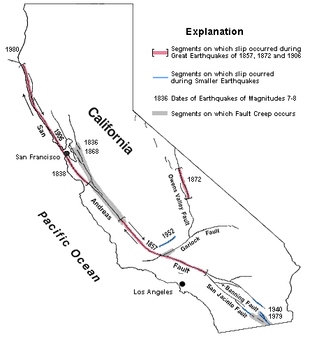
Historic Earthquakes of California
Listed below are the major historic earthquakes with a magnitude of 6 or greater that have hit California prior to the year 2000. The top ten earthquakes of California are highlighted in dark yellow, and their ranking given in blue. Some honorable mentions are highlighted in light yellow.
| DATE |
MAGNITUDE &
(RANKING) |
LOCATION |
| July 28, 1769 |
6.0 |
Los Angeles Basin |
| Nov 22, 1800 |
6.5 |
*** San Diego region *** |
| June 24, 1808 |
6.0 |
San Francisco region |
| Dec 8, 1812 |
7.0 (10) |
San Juan Capistrano (Wrightwood) |
| Dec 21, 1812 |
7.1 |
Santa Barbara Channel (Lompoc) |
| Sept 24, 1827 |
5.5 |
Los Angeles region |
| June 10, 1836 |
6.75 |
Hayward Valley |
| June 1838 |
7.0 |
San Francisco Peninsula |
| July 11, 1855 |
6.0 |
Los Angeles region |
| Feb 15, 1856 |
5.5 |
San Francisco Peninsula |
| Jan 9, 1857 |
8.25 (1) |
Great Fort Tejon Earthquake |
| Sept 3, 1857 |
6.25 |
West Nevada or East Sierra Nevada |
| Nov 26, 1858 |
6.25 |
San Jose region |
| Dec 16, 1858 |
6.0 |
San Bernardino region |
| May 27, 1862 |
6.0 |
*** San Diego region *** |
| Feb 26, 1864 |
6.0 |
South Santa Cruz Mountains |
| March 5, 1864 |
5.75 |
East of San Francisco Bay |
| Oct 8, 1865 |
6.5 |
South Santa Cruz Mountains |
| July 15, 1866 |
6.0 |
West San Joaquin Valley |
| Oct 21, 1868 |
7.0 |
Hayward fault |
| Feb 17, 1870 |
6.0 |
Los Gatos |
| March 2, 1871 |
6.0 |
Cape Mendocino |
| March 26, 1872 |
7.6 |
Owens Valley |
| March 26, 1872 |
7.6 (4) |
Owens Valley |
| April 3, 1872 |
6.25 |
Owens Valley |
| April 11, 1872 |
6.75 |
Owens Valley |
| May 3, 1872 |
5.75 |
Imperial Valley |
| Nov 23, 1873 |
6.75 |
Crescent City |
| Jan 24, 1875 |
6.0 |
Honey Lake |
| Nov 15, 1875 |
6.25 |
Imperial Vly to Colorado River delta |
| Feb 2, 1881 |
5.75 |
Parkfield |
| April 10, 1881 |
6.0 |
West San Joaquin Valley |
| March 6, 1882 |
5.75 |
Hollister |
| Sept 5, 1883 |
6.25 |
Santa Barbara Channel |
| Jan 28, 1884 |
5.75 |
Klamath Mountains |
| March 26, 1884 |
6.0 |
Santa Cruz Mountains |
| Jan 31, 1885 |
5.75 |
Susanville |
| April 12, 1885 |
6.25 |
South Diablo Range |
| April 29, 1888 |
6.0 |
Mohawk Valley |
| May 19, 1889 |
6.25 |
Antioch |
| June 20, 1889 |
6.0 |
Susanville |
| Sept 30, 1889 |
5.75 |
Bishop region |
| Feb 9, 1890 |
6.5 |
San Jacinto or Elsinore fault region |
| April 24, 1890 |
6.25 |
Pajaro Gap |
| July 26, 1890 |
6.25 |
Cape Mendocino |
| July 30, 1891 |
6.0 |
Colorado River delta region |
| April 19, 1892 |
6.5 |
Vacaville |
| April 21, 1892 |
6.25 |
Winters |
| May 28, 1892 |
6.5 |
San Jacinto or Elsinore fault region |
| Nov 13, 1892 |
5.75 |
Hollister |
| May 19, 1893 |
5.75 |
Pico Canyon |
| July 30, 1894 |
6.0 |
Lytle Creek region |
| Sept 30, 1894 |
6.0 |
Cape Mendocino region |
| Oct 23, 1894 |
5.75 |
*** East of San Diego *** |
| Aug 17, 1896 |
6.0 |
SE Sierra Nevada |
| June 20, 1897 |
6.25 |
Gilroy |
| March 31, 1898 |
6.5 |
Mare Island |
| April 15, 1898 |
6.5 |
Mendocino |
| April 16, 1899 |
7.0 |
West of Eureka |
| July 6, 1899 |
5.75 |
Morgan Hill |
| July 22, 1899 |
5.75 |
Lytle Creek region |
| Dec 25, 1899 |
6.6 |
San Jacinto and Hemet |
| March 3, 1901 |
6.4 |
Parkfield |
| Jan 24, 1903 |
6.6 |
Colorado River delta region |
| June 11, 1903 |
5.5 |
San Jose |
| Aug 3, 1903 |
5.5 |
San Jose |
| April 18, 1906 |
8.25 (2) |
Great San Francisco Earthquake |
| April 19, 1906 |
6.2 |
Imperial Valley |
| April 23, 1906 |
6.4 |
Arcata |
| Sept 20, 1907 |
5.3 |
San Bernardino region |
| Nov 4, 1908 |
6.0 |
Death Valley region |
| Oct 29, 1909 |
5.8 |
Cape Mendocino |
| March 11, 1910 |
5.8 |
Watsonville |
| March 19, 1910 |
6.0 |
West of Cape Mendocino |
| May 15, 1910 |
5.5 |
Glen Ivy Hot Springs |
| Aug 5, 1910 |
6.6 |
West of Crescent City |
| July 1, 1911 |
6.5 |
Calaveras fault |
| Feb 18, 1914 |
5.5 |
Truckee region |
| April 24, 1914 |
6.0 |
Truckee region |
| May 6, 1915 |
6.2 |
West of Cape Mendocino |
| June 23, 1915 |
6.0 |
Imperial Valley |
| June 23, 1915 |
5.9 |
Imperial Valley |
| Dec 31, 1915 |
6.5 |
West of Eureka |
| Oct 23, 1916 |
5.3 |
Tejon Pass region |
| Nov 10, 1916 |
6.1 |
South of Death Valley |
| April 21, 1918 |
6.6 |
San Jacinto |
| July 15, 1918 |
6.5 |
West of Eureka |
| Jan 26, 1922 |
6.0 |
West of Eureka |
| Jan 31, 1922 |
7.3 |
West of Eureka |
| Jan 22, 1923 |
7.2 |
Cape Mendocino |
| July 23, 1923 |
6.0 |
San Bernardino region |
| June 4, 1925 |
6.0 |
West of Eureka |
| June 29, 1925 |
6.3 |
Santa Barbara |
| Oct 22, 1926 |
6.1 |
Monterey Bay |
| Oct 22, 1926 |
6.1 |
Monterey Bay |
| Dec 10, 1926 |
6.0 |
West of Cape Mendocino |
| Sept 18, 1927 |
6.0 |
Bishop region |
| Nov 4, 1927 |
7.3 |
SW of Lompoc |
| June 6, 1932 |
6.4 |
Eureka |
| March 11, 1933 |
6.4 |
Long Beach |
| June 8, 1934 |
6.0 |
Parkfield |
| July 6, 1934 |
6.5 |
West of Eureka |
| Dec 31, 1934 |
7.0 |
Colorado River delta |
| Feb 24, 1935 |
5.3 |
Colorado River delta |
| June 3, 1936 |
5.9 |
West of Cape Mendocino |
| March 25, 1937 |
6.0 |
Buck Ridge |
| Feb 8, 1940 |
6.0 |
Chico |
| May 19, 1940 |
7.1 (7) |
Imperial Valley |
| Dec 7, 1940 |
5.5 |
Colorado River delta |
| Feb 9, 1941 |
6.6 |
West of Cape Mendocino |
| April 9, 1941 |
5.3 |
Gulf of California |
| May 13, 1941 |
6.0 |
West of Cape Mendocino |
| July 1, 1941 |
5.9 |
Carpenteria |
| Sept 14, 1941 |
6.0 |
Tom's Place |
| Sept 14, 1941 |
5.8 |
Tom's Place |
| Oct 3, 1941 |
6.4 |
West of Cape Mendocino |
| Oct 21, 1942 |
6.6 |
Fish Creek Mountains |
| May 19, 1945 |
6.2 |
West of Cape Mendocino |
| Sept 28, 1945 |
6.0 |
West of Crescent City |
| March 15, 1946 |
6.3 |
Walker Pass (Kern County) |
| April 10, 1947 |
6.5 |
Manix (San Bernadino County) |
| Dec 4, 1948 |
6.5 |
Desert Hot Springs (Riverside County) |
| March 25, 1949 |
6.2 |
West of Eureka |
| May 2, 1949 |
5.9 |
Pinto Mountain |
| Oct 8, 1951 |
6.0 |
West Of Cape Mendocino |
| Dec 26, 1951 |
5.9 |
San Clemente Island |
| July 21, 1952 |
7.7 (3) |
Bakersfield (Kern County) Earthquake |
| July 21, 1952 |
6.4 (aftershock) |
Bakersfield (Kern County) |
| July 23, 1952 |
6.1 (aftershock) |
Bakersfield (Kern County) |
| July 29, 1952 |
6.1 (aftershock) |
Bakersfield (Kern County) |
| Aug 22, 1952 |
5.8 (aftershock) |
Bakersfield (Kern County) |
| Nov 22, 1952 |
6.0 |
Bryson |
| Jan 12, 1954 |
5.9 |
West of Wheeler Ridge |
| March 19, 1954 |
6.2 |
Arroyo Salada |
| Nov 25, 1954 |
6.5 |
West of Cape Mendocino |
| Dec 21, 1954 |
6.6 |
East of Arcata |
| Oct 11, 1956 |
6.0 |
West of Cape Mendocino |
| Dec 13, 1956 |
6.0 |
West shore, Gulf of California |
| Aug 9, 1960 |
6.2 |
West of Cape Mendocino |
| June 28, 1966 |
6.0 |
Parkfield |
| Aug 7, 1966 |
6.3 |
Gulf of California |
| Sept 12, 1966 |
6.0 |
Truckee |
| April 9, 1968 |
6.5 |
Borrego Mountain |
| Feb 9, 1971 |
6.6 |
San Fernando |
| Feb 21, 1973 |
5.2 |
Point Mugu |
| Nov 26, 1976 |
6.3 |
West of Orick |
| Aug 6, 1979 |
5.7 |
Coyote Lake |
| Oct 15, 1979 |
6.4 |
Imperial Valley |
| Jan 24, 1980 |
5.8 |
Livermore |
| May 25, 1980 |
6.1 |
Mammoth Lakes |
| May 25, 1980 |
5.9 |
Mammoth Lakes |
| May 25, 1980 |
5.8 |
Mammoth Lakes |
| May 27, 1980 |
6.0 |
Mammoth Lakes |
| Nov 8, 1980 |
7.2 |
West of Eureka |
| April 26, 1981 |
6.0 |
Westmorland |
| Sept 4, 1981 |
5.9 |
North of Santa Barbara Island |
| Sept 30, 1981 |
5.8 |
Mammoth Lakes |
| May 2, 1983 |
6.5 |
Coalinga Earthquake |
| July 22, 1983 |
5.7 |
Coalinga (aftershock) |
| April 24, 1984 |
6.1 |
Morgan Hill |
| Sept 10, 1984 |
6.7 |
Mendocino Fracture Zone |
| Nov 23, 1984 |
5.7 |
Round Valley |
| Aug 4, 1985 |
5.9 |
North Kettleman Hills |
| July 8, 1986 |
6.0 |
North Palm Springs |
| July 20, 1986 |
5.6 |
Chalfant Valley |
| July 21, 1986 |
6.2 |
Chalfant Valley |
| July 31, 1986 |
5.2 |
Chalfant Valley |
| Oct 1, 1987 |
5.8 |
Whittier Narrows |
| Nov 24, 1987 |
6.2 |
Elmore Ranch fault |
| Nov 24, 1987 |
6.6 |
Superstition Hills |
| Oct 17, 1989 |
7.1 (8) |
Loma Prieta |
| Aug 16, 1991 |
6.3 |
West of Crescent City |
| Aug 17, 1991 |
7.1 |
West of Crescent City |
| April 23, 1992 |
6.1 |
Joshua Tree |
| April 25, 1992 |
7.2 (6) |
Cape Mendocino |
| April 26, 1992 |
6.5 (aftershock) |
Cape Mendocino |
| April 26, 1992 |
6.6 (aftershock) |
Cape Mendocino |
| June 28, 1992 |
7.3 (5) |
Landers |
| June 28, 1992 |
6.2 |
Big Bear |
| May 17, 1993 |
6.1 |
Big Pine |
| Jan 17, 1994 |
6.7 |
Northridge |
| Sept 1, 1994 |
6.9 |
Mendocino Fracture Zone |
| Feb 19, 1995 |
6.6 |
West of Eureka |
| Sept 20, 1995 |
5.5 |
Ridgecrest |
| July 24, 1996 |
5.7 |
West of Eureka |
| Oct 16, 1999 |
7.1 (9) |
Hector Mine |
| Sept. 3, 2000 |
5.0 |
North San Francisco Bay |
| Dec. 22, 2003 |
6.6 |
Central Coast |
| Oct. 30, 2007 |
5.6 |
South San Francisco Bay |
| July 29, 2008 |
5.5 |
Greater Los Angeles Area |
| Jan. 9, 2010 |
6.5 |
Cape Mendocino |
| April 4, 2010 |
7.2 |
Baja California |
| Aug. 24, 2014 |
6.0 |
South Napa County Earthquake |
The above table from 1769 to 2004 is based on "California Earthquake History 1769-present", which is a list put together by the United States Geological Survey (USGS). Updates on recent earthquakes from 2005 to the present are based on entries in Wikipedia. The magnitudes that the USGS gives for earthquakes after 1898 are similar to the famous Richter scale, in which the magnitude, more or less, represents the energy of the earthquake. This value is calculated from the distance that the needle on a seismograph moves during an earthquake. Thus, it depends on the amplitude of the surface wave associated with the quake. Because seismographs were not available prior to 1898, the magnitudes of earthquakes prior to then must be estimated from the intensity of damage associated with the quake as reported by witnesses to the event. The links below give more information.
Richter Scale
Mercalli Intensity
Listed below are the top ten earthquakes to have hit California in historic times. Again the sizes of earlier quakes are estimates, and they will differ depending on which authority is being consulted. For example, some scientists believe that the 1857 Tejon earthquake was the largest to hit California in historic times, and other experts rank the San Francisco Earthquake of 1906 as the larger of the two.
| RANK |
DATE |
MAGNITUDE |
LOCATION |
| 1 |
Jan 9, 1857 |
8.25 |
Fort Tejon Earthquake |
| 2 |
April 18, 1906 |
8.25 |
San Francisco Earthquake |
| 3 |
July 21, 1952 |
7.7 |
Bakersfield Earthquake |
| 4 |
March 26, 1872 |
7.6 |
Owens Valley |
| 5 |
June 28, 1992 |
7.3 |
Landers |
| 6 |
April 25, 1992 |
7.2 |
Cape Mendocino |
| 7 |
May 19, 1940 |
7.1 |
Imperial Valley |
| 8 |
Oct 17, 1989 |
7.1 |
Loma Prieta |
| 9 |
Oct 16, 1999 |
7.1 |
Hector Mine |
| 10 |
Dec 8, 1812 |
7.0 |
San Juan Capistrano |
|

|